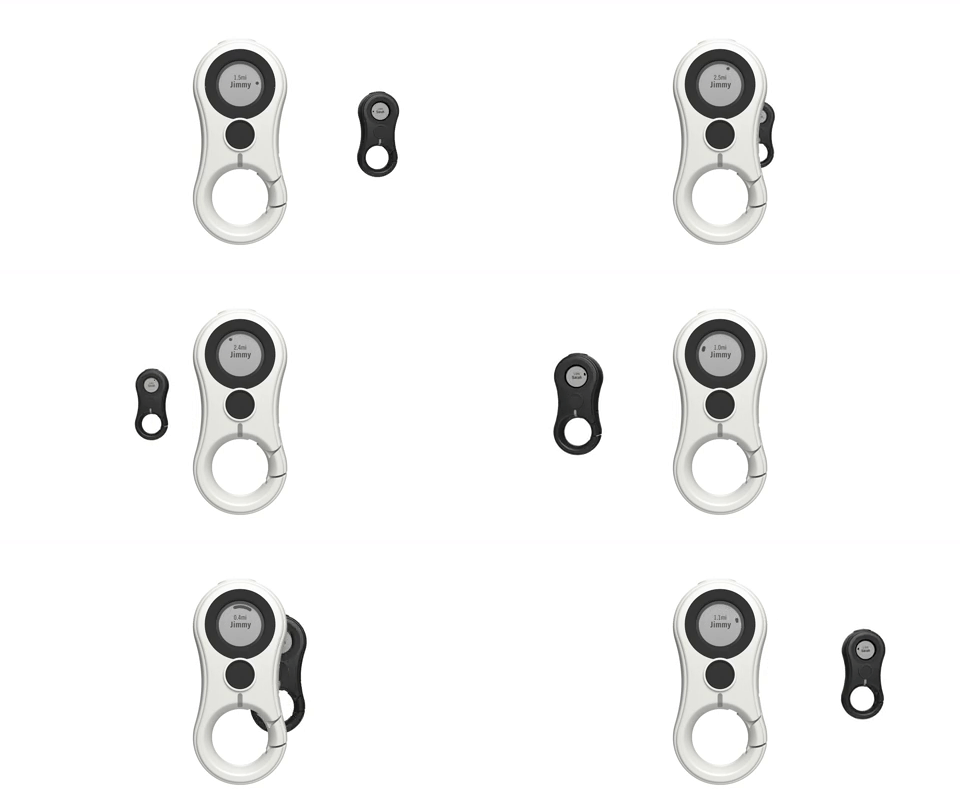
Lynq – The Tracking Device that Requires No Connectivity and Works Without CellPhone
Have you ever been to a concert with no way to find the friends you were supposed to meet, seems like things could not get worse but there is no signal and Google map is not working (even when it does, it won’t pinpoint where they are)? Yes, I know a lot of people can relate to this situation. It might not have been at a concert, could have been in a conference, during hiking, cycling events or a beach party. A solution to this problem might be a recent crowdfunded product called Lynq.
Lynq is a convenient little device that’ll not only help you locate your friends and family in the great outdoors, but it might even save lives. Lynq is an ultimate tracker which gives direction and distance without the aid of connectivity or maps.
Lynq is a 4″x2″x1″ sized tracking device that works with a 3-mile range, it has been tested under various conditions according to the makers and has been declared to have the capability to work anywhere. A capable waterproof and rugged device that can work in the most extreme harsh environment as well.
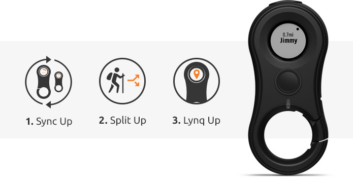
There are two stages involved when using the Lynq tracking device. The first step is the synchronization stage; with set up of the device you are able to connect to other devices one wants to track. Lynq can connect to a maximum of 15 other Lynq devices. Once you are done with the synchronization stage, everyone is free to roam along as they are within 5 kilometers range. The next thing after splitting up is the linking stage. You link up or should I say Lynq link up with the rest of your group. Just follow the directional indicator displayed on the screen to find them. One can also create or set up a safe zone or meeting point where everyone is supposed to return to.
The device comes in an hourglass shape, and it weighs 73 grams including the weight of the batteries. The battery can last for up to 3 days without charging. The GPS accuracy is 12 to 15 feet, and the accuracy of the directional indicator is 5 degrees. Lynq makes use of proprietary algorithms and communications protocols that combine low power radio, GPS and a custom antenna without the aid of sensors. USB cable for charging, a quick setup card, and a registration card come with the product.
The company is thinking of including an optional connectivity application for people interested in connecting to their mobile phones. The product has a one year warranty for wears and tears or other manufacturing defects. Lynq adheres to the standard privacy policy and does not keep a record of the locations you enter after you successfully get to your destination and there is no way any other person can listen to you or watch you via the device, so it is safe.
Lynq is available for pre-order on the Indiegogo campaign page with a starting price of $89. More information about the Lynq tracking device can be found on the product campaign page.








This thing sounds cool! I can think of several uses (put one on you car so you can find it in a huge parking lot after an event, on your kid at Disney World, on a Drone, Near Space Balloon…)
Can anyone think of a way to reverse-engineer this thing and put a DIY version in the public domain, or should I just wait for Chinese companies to flood the market with cheap clones?
Yeah, it’s so cool and awesome. I thought about the DIY route, but I haven’t yet figured out the wireless connectivity it use. I know it probably use some ubox GPS unit or something similar, but GPS can’t give you that sort of precision it demonstrated alone, so there must be something else accompanying it.
Any ideas, please let us know.
If uniquely named devices could Instant Message (or equivalent) their GPS Coordinates to each other; each could figure out the distance and direction to any other one (including altitude.) All that’s really needed is a private channel for the Apps to talk to each other (i.e. method to broadcast to nearby devices.) With web access, a common server could relay the information for world-wide distances, not just the 3 mile range of this thing.
Yeah, that’s true. But it doesn’t use any web or app access to achieve this. With some digging out, It uses GPS in connection with an unnamed low power radio to connect several devices together. I believe the low power radio is what gives it the 3 mil radius. With the range of the radio and GPS coordinate, it’s possible for the device to create a kinetic positioning of the other devices.
I think it is actually possible to easily build a DIY version of this device, it is actually easier than thought.
Communications Protocol:
This basic Protocol works for either Device to nearby Device(s) (i.e. 3 mile range,) or Device to Web Server (world-wide.)
You would register with other Device(s) or Web Server with a Unique Device Name (i.e. “Bob’s Device”), and keep a list of other device names you want to track. Each device sends location information every few seconds/minute; and requests location of device names they’re tracking.
Send Location:
Device –> SEND,,,,;
Reply <– SEND_ACK,;
Request Location:
Device –> REQUEST,[,…];
Reply <– REQUEST_ACK,,,,[,,,,…];
Example Data:
Bob puts one device on his Cat so he knows where it is, and one on his Drone so he doesn’t lose it. Every few seconds the following takes place…
Bob’s Device –> SEND,Bob’s Device,38.111111,-97.111111, 101.1;
SEND,Whiskers,38.222222,-97.222222,102.2;
SEND,Bob’s Drone,38.333333,-97.333333,133.3;
;
Bob’s Device –> REQUEST,Whiskers,Bob’s Drone;
<– REQUEST_ACK,Whiskers,38.222222,-97.222222,102.2,Bob's Drone,38.333333,-97.333333,133.3;
Bob's Device then calculates the distance/direction between its location and the other locations.
38.222222 – 38.111111 = Cat's Lat Delta 0.111111
-97.222222 – -97.111111 = Cat's Long Delta -0.111111
102.2 – 101.1 = Cat's Altitude Delta 1.1
38.333333 – 38.111111 = Drone's Lat Delta 0.222222
-97.333333 – -97.111111 = Drone's Long Delta -0.222222
133.3 – 101.1 = Drone's Altitude Delta 32.2
This could easily be set up for Smartphones with a Web Server to support the App; sent over http for error correction, or https for privacy.
The Database could also include a Timestamp and an additional Flag in the Reply Protocol to indicate stale data; or use last known location, speed, and direction to estimate current location(s) (Dead Reckoning.)
And if you really, really, REALLY have to… monetize it by sending an Advertising Link in the Reply Protocol every few minutes that gets displayed in a small, non-intrusive window (i.e. Reply <– ADVERTISMENT,http://www.FreeLYNQ.com😉 (Free version, removed for paid accounts.)